Fiùra:Muscovy 1390 1525.png
Nun ce sta na risoluzione cchiù auta.
Muscovy_1390_1525.png (440 × 425 pixel, dimenzione ddo file: 135 KB, tipo MIME: image/png)
| Descrizzione |
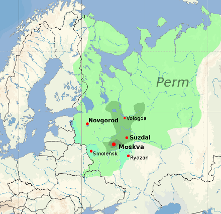
English: Territorial expansion of the Grand Duchy of Moscow, 1300–1547
Core territory of Muscovy, 1300
Territory of Vladimir-Suzdal, acquired by Muscovy by 1390
Territory acquired by 1505 (Ivan III)
Territory acquired by 1533 (Vasili III)
Modern national borders are shown for orientation. |
|||
| Data | ||||
| Funte |
blank map: File:Europe location POR.png. Territorial boundaries based on File:Moscow1500.png, File:Kievan-rus-1015-1113-(en).png, File:Muscovy 1300-1462.png. See also File:Russia 1533-1896.gif. See talkpage for discussion of the sources used. Information on historical territory relies on maps uploaded by ru:Участник:Koryakov Yuri (2008). |
|||
| Autore | Dbachmann | |||
| Premmesse (Riausanno stu file) |
derivative work based on the blank map by David Liuzzo.
|

.png)

|
Questa immagine (categorizzazione automatica: historical map) o tutte le immagini in questa categoria o galleria dovrebbero essere ricreate usando grafica vettoriale come file SVG. Questo offre diversi vantaggi: vedi Commons:Media for cleanup per maggiori informazioni. Se è disponibile una versione in formato SVG di questa immagine, per favore caricala. Dopo aver caricato un file SVG, sostituisci questo avviso con il template {{Vector version available|nome_immagine.svg}}.
|
Cronologgia d’’o file
Fa’ clic ncoppa a na data/ora pe vedé comme s'appresentava 'o file a chillo mumento.
| Data/Ora | Miniatura | Dimenzione | Utente | Commento | |
|---|---|---|---|---|---|
| attuale | 18:20, 23 Jen 2022 | | 440 × 425 (135 KB) | Ориенталист | Reverted to version as of 16:40, 5 October 2020 (UTC) See File:Russo–Lithuanian Wars-1500 campaign-rus0.2.svg This territories became part of Russia during Ivan III |
| 12:09, 2 dic 2021 |  | 440 × 425 (170 KB) | Dbachmann | Reverted to version as of 13:12, 17 April 2011 (UTC) -- I am sorry, please explain the change, you cannot just say "more accurate" without changing the references to the sources this is based on. | |
| 18:40, 5 ott 2020 |  | 440 × 425 (135 KB) | Ориенталист | More accurate | |
| 15:12, 17 Abb 2011 |  | 440 × 425 (170 KB) | Dbachmann | update | |
| 14:42, 17 Abb 2011 |  | 450 × 438 (212 KB) | Dbachmann | {{Information |Description ={{en|1=Grand Duchy of Moscow (Muscovy) between 1390 and 1547}} |Source =blank map: File:Europe location POR.png |Author =Dbachmann |Date =2011 |Permission = {{Copyrighted free use provided |
Jonte ê ffiure
Pe' nisciuna paggena ce buò stu file.
Auso globbale d’’o file
'E wiki ccà abbascio aúsano stu file:
- Uso ncopp'a af.wikipedia.org
- Uso ncopp'a arz.wikipedia.org
- Uso ncopp'a ast.wikipedia.org
- Uso ncopp'a ba.wikipedia.org
- Uso ncopp'a be-tarask.wikipedia.org
- Uso ncopp'a be.wikipedia.org
- Uso ncopp'a ca.wikipedia.org
- Uso ncopp'a ce.wikipedia.org
- Uso ncopp'a cs.wikipedia.org
- Uso ncopp'a cy.wikipedia.org
- Uso ncopp'a da.wikipedia.org
- Uso ncopp'a de.wikipedia.org
- Uso ncopp'a el.wikipedia.org
- Uso ncopp'a en.wikipedia.org
- Uso ncopp'a en.wikibooks.org
- Uso ncopp'a en.wiktionary.org
- Uso ncopp'a eo.wikipedia.org
- Uso ncopp'a es.wikipedia.org
- Uso ncopp'a et.wikipedia.org
- Uso ncopp'a eu.wikipedia.org
- Uso ncopp'a fa.wikipedia.org
- Uso ncopp'a fi.wikipedia.org
- Uso ncopp'a fr.wikipedia.org
Vedite ause globbale 'e stu file.